
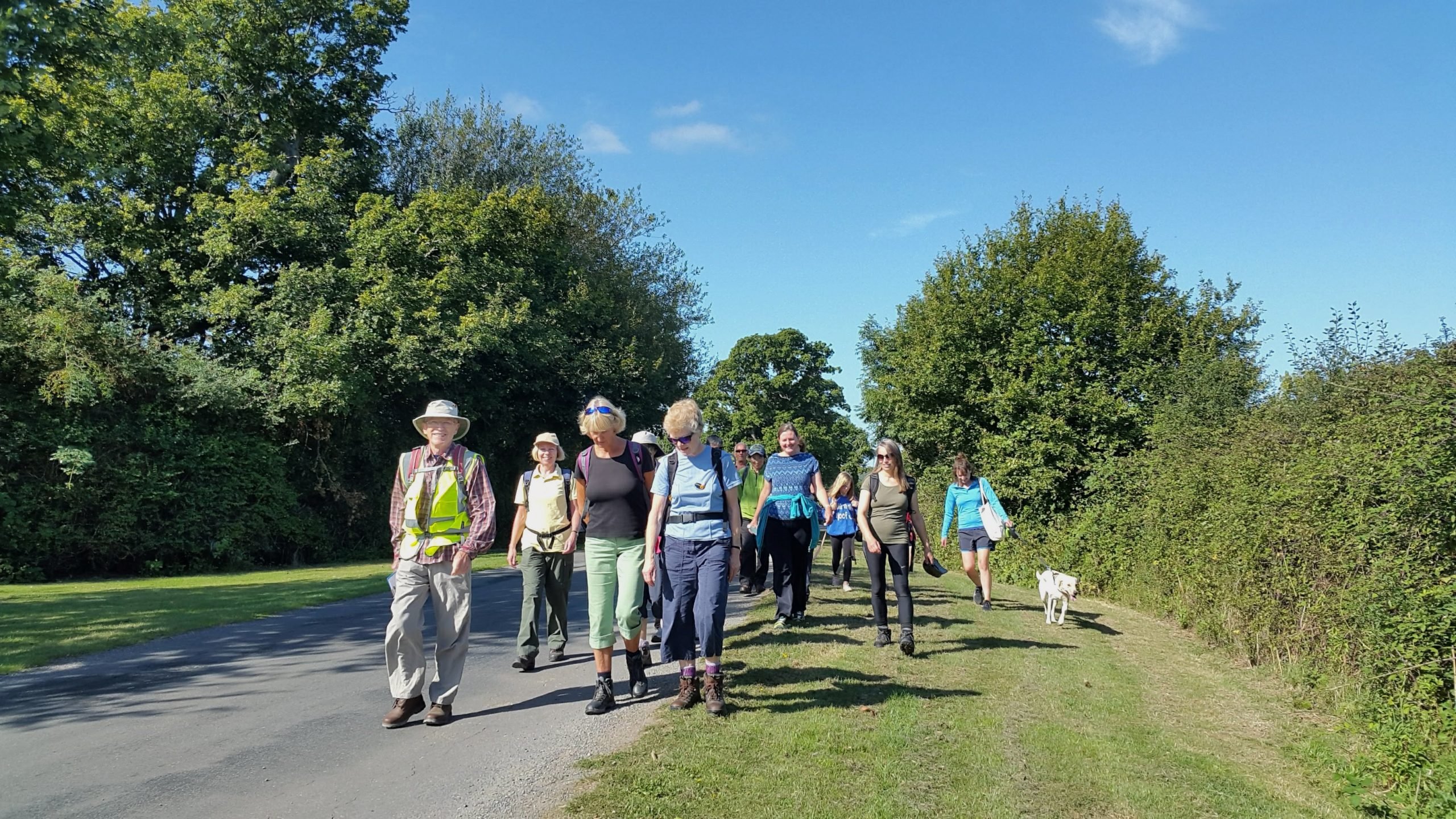
Walking
Welcome to our collection of self-guided walks in Kent and Sussex, showcasing the very best of this outstanding landscape.
The High Weald has an amazing network of footpaths, bridleways and byways to explore – 2,570km in total!
From families with young children to avid ramblers and everyone in-between, this precious landscape has something for everyone to enjoy.
You can explore the area’s ancient woodland, fields and heaths at your own pace with a range of downloadable self-guided walks, including easy-access routes that are both buggy and wheelchair friendly. If you’re after a challenge, why not take on the iconic 95-mile High Weald Landscape Trail?
In September, join our annual High Weald Walking Festival and choose from a programme of free themed walks led by knowledgeable guides.
The AONB is also home to a number of tranquil nature reserves, owned and managed by the RSPB, Wildlife Trusts, Woodland Trust, National Trust and local community groups.
Use the interactive map to explore a specific area or choose from the options below.
Happy walking!
2,570km
of public rights of way in the High Weald AONB!
Things to do
Places to visit
Sterling Venison
M & M Venison
Supplier of Fallow Deer venison that has been culled in the Ashdown Forest area and butchered in Sussex ready for eating.
Our Butcher can cut the animal as you wish and many buyers take the whole animal, cut to their requirements and vacuum packed.
Buying the whole animal is very cost effective and only takes one vehicle trip so good for the planet.
Call Mark on 07850 794620 or email marksmudgersmith@btinternet.com.
Otways Meat and Game
Our wild venison is ethically sourced by our in-house deer management team from a number of estates in the South East.
Since we opened our doors, Otways Meat and Game has become an integral part of the local community. We started the business after realising it wasn’t always easy to source the highest-quality fresh, local venison. We’ve worked hard to build strong relationships with our incredible clients; come and explore our busy butchery and discover the true meaning of delicious.
Ali Otway
07827 932 155
Contact: alison@otwaysmeatandgame.com
Kieron’s Game
Penns Estate Venison LTD
Eridge Park Venison
Halfway to a homestead
Sustainable Meat Eater
Wild venison harvested in the Kent, Sussex and Surrey countryside. Expertly prepared and delivered to your door.
Contact 07733278574
Yew House Bed & Breakfast
Bed and breakfast accommodation in Crowborough, East Sussex.
Visit websiteWaters End Farm
Self catering and bed and breakfast accommodation near Cranbrook, Kent
Visit websiteThe Potting Shed
Powdermills Hotel
18th century country house hotel accommodation near Battle, East Sussex
Visit websitePark Farm Caravan and Camping
Caravan and campsite set in the heart of the Sussex countryside
Visit websiteBrantridge Park
Luxury self catering apartments in an historic building in Balcombe, West Sussex
Visit websiteTrails by Rail: Robertsbridge
Discover the pretty, historic village of Robertsbridge, walking across farmland and through ancient woodland with fantastic views across the High Weald landscape.
This 5-mile walks starts and ends at Robertsbridge train station. Please note this is a hilly route with 17 stiles.
Look out for an oast house, ancient trees, streams and historic buildings on the way.
- Parking: pay and display parking at Robertsbridge Station or a few long stay places free at the public car park, Station Road.
- Refreshments: Judges Bakery on the High Street and the George Inn. Village shop
Fox & Fox – Mayfield English Wine
English sparkling wines produced in the heart of the High Weald.
Visit websiteTottingworth Farm Shop
Farm shop with a range of local produced meats and other products
Visit websiteTibbs Farm
Soft fruit farm offering PYO, plus a café serving farm to fork food with stunning views.
Visit websitePowdermill Wood
A range of coppice chestnut products, including chestnut fencing and garden products
Visit websitePlanters Farm Shop
A farm shop and garden centre selling a wide range of products plus a café swerving delicious home cooked food
Visit websitePerry Hill Orchard Farm Shop
Farm shop selling own juices and ciders and a range of other products
Visit websiteHunts Sussex Cider
Micro brewery selling cider made from organically grown apples - vegan friendly and gluten free.
Visit websiteFirebird Forge
A traditional blacksmith offering personally designed, hand forged, ironwork for home and garden.
Visit websiteHorsegrove Farm
Rare breed, homegrown beef, lamb and pork – only 20 food miles form start to finish!
Visit websiteGreen Wood Craftsmen
Bluebell Vineyard Estates
Home to the Hindleap range of internationally acclaimed English Sparkling Wines, handmade by the traditional method in East Sussex.
Visit websiteBiddenden Vineyards
Vineyard shop selling wines, ciders and juices, also other local products
Visit websiteWinchelsea Court Hall Museum
Brede Steam Giants
The Amelia Scott
Bodiam Castle
Tulleys Farm
Worth Way – Circular routes
A selection of circular walks on the Worth Way, which runs from Three Bridges in Crawley to East Grinstead where it connects up with the Forest Way.
Get walking!Walks around Rye Harbour
A selection of different length walks around Rye Harbour nature reserve
Get walking!Trails by Rail: Winchelsea
A 6.5 mile circular walk exploring Winchelsea and surrounding farmland, starting and finishing at the train station. Enjoy fantastic views of the Brede river valley and across Pett Levels to the sea.
Please note this route includes 11 stiles.
Parking: parking bays on the A259 near the junction of Station Road. Start the walk at that junction.
Refreshments: The New Inn at Winchelsea and village store.
Trails by Rail: Wadhurst
Enjoy a 5.5 mile circular walk down through wooded valleys, along historic pathways and over farmland with spectacular views across the rolling hills and medieval fields of the High Weald AONB.
This walk starts and ends at Wadhurst train station. Look out for ponds, ancient woodland and sunken routeways.
- Parking: pay and display parking at Wadhurst Station.
- Refreshments: None nearby, lots of choice at Wadhurst
village (1 mile)
Trails by Rail: Eridge
A 5.5 mile circular walk around Eridge and Harrisons Rocks, starting and ending at Eridge station. Enjoy a walk across gently rolling hills with views across wooded valleys.
A highlight is Harrisons Rocks, a spectacular sandstone outcrop which is one of the largest in the AONB. Oast houses, WW2 pill boxes and gill streams are other features to look out for.
- Parking: pay and display parking at Eridge Station, with
some free off-road parking outside the station. - Refreshments: The Huntsman.
Trails by Rail: Buxted
This 4 mile walks starts and ends at Buxted train station, taking in some of the best of the High Weald’s iconic scenery.
Enjoy a gentle walk across farmland, alongside Tickerage Stream and through historic Buxted Park with a circuit around the ancient woodland of Views Wood.
Look out for an historic churchyard, ornamental ponds and an ancient
yew thought to be 2,000 years old.
- Parking: pay and display at Buxted Station or occasional
spaces along nearby roads. - Refreshments: The White Hart near the station, Buxted Inn,
Buxted Park Hotel (drinks on the veranda recommended)
and village store
Trails by Rail: Balcombe
This 6-mile circular walk, starting and ending at Balcombe train station, takes you through wooded valleys and over gently rolling hills with spectacular views over the Ouse valley, the railway viaduct and the South Downs.
Look out for sunken lanes, ponds, a sandstone outcrop and historic buildings.
- Time: approx 3 hours
- Parking: pay and display parking at Balcombe Station
- Refreshments: Balcombe Tea Rooms, the Half Moon Inn,
village store.
Ticehurst walk
A 7 mile circular walk through Ticehurst and along part of the edge of Bewl Reservoir
Get walking!Southborough Circulars
3 circular walks exploring Southborough Common - one of the oldest common spaces in the UK. Choose from 'Habitats Circular', 'Veterans Tour' or the 10-mile 'Secrets Circular'.
Get walking!Sissinghurst: A Walk Through Time
Rushlake Green walk
A 4.5 mile circular walk around the countryside near to Rushlake Green
Get walking!National Trust – Standen to Selsfield Common
An 8.5 mile walk starting from Standen and takes you to Selsfield Common
Get walking!National Trust – Sprivers walk
A 1-mile circular walk through the woods around Sprivers Wood in Kent. Please note parking is limited at this site.
Get walking!National Trust – Sissinghurst Castle walk
A 3 mile walk exploring Sissinghurst Castle's gardens and grounds
Get walking!National Trust – Nymans Woodland Walks
National Trust – Nap walk
A 1 mile circular walk around a woodland owned by the National Trust
Get walking!National Trust – Bateman’s
A selection of 3 walks through the beautiful 300-acre Bateman’s Estate
Get walking!Herstmonceux walk
A 4 mile circular walk around Herstmonceux Castle and the Royal Observatory
Get walking!Fairlight maritime walk
An 8 mile circular walk around Fairlight taking in the area's maritime history
Get walking!Discovering Britain: Burwash walk
Crowhurst Walk
A 3.5 mile walk around the village of Crowhurst and through Fore Wood, an RSPB reserve
Get walking!Burwash walk
A 7 mile circular walk around Burwash and Burwash Weald.
Please note this route has not been updated for some time so some information may be out of date. We always recommend taking an OS map when out walking in the High Weald AONB.
Get walking!Broadwater Warren history trail
A 2 mile walk around Broadwater Warren highlighting the site’s rich history
Get walking!Ashdown Forest Walk 6: Broadstone Amble
A 2.5 mile circular, waymarked walk starting at the Ashdown Forest Visitor Centre
Please note parking charges apply.
Get walking!Broad Oak walk
This 3 mile walk is around Broad Oak and Brede villages.
Please note this route has not been updated for some time, so some information may be out of date. We always recommend taking an OS map with you when walking in the High Weald AONB.
Get walking!Bodiam Castle walk
A 5 mile circular walk around Bodiam castle and along the river Rother
Get walking!Beckley walk
A 3 mile walk through the woods around Beckley. This is a generally easy walk with stiles and some muddy paths (depending on weather).
Get walking!Ashdown Forest Walk: Forest Row
A 3.5 mile easy circular walk with some gentle hills and stiles
Get walking!Ashdown Forest Walk 8: A walk amongst friends
A 1.7 miles / 2.8 km circular walk on Ashdown Forest taking in Friends Clump, Nutley Windmill, Millbrook Valley and Old Lodge.
Please note parking charges apply.
Get walking!Ashdown Forest Walk 7: Eastern clumps
Two short circular walks, 1.4 or 2.2 miles from Kings Standing on Ashdown Forest.
Please note parking charges apply.
Get walking!Ashdown Forest Walk 5: Old Airstrip
A 2.5 mile circular walk on Ashdown Forest, exploring the largest block of heathland on the West side of the forest
Please note parking charges apply.
Get walking!Ashdown Forest Walk 3: Chelwood Vachery
A 2.75 mile walk around Chelwood Vachery on Ashdown Forest.
Please note parking charges apply.
Get walking!Ashdown Forest Walk 2: Southern slopes and the airman’s grave
A 2-mile circular walk on Ashdown Forest, taking in a lonesome memorial to a WW2 pilot.
Please note parking charges apply.
Get walking!Ashdown Forest Walk 11: Chelwood Gate archaeology walk
A 3 mile circular walk around Chelwood Gate.
Get walking!Ashdown Forest Walk 10: Beyond the Pale
A 2.5 mile circular walk on Ashdown Forest starting from Goat car park.
Please be advised parking charges apply.
Get walking!Ashdown Forest Walk 1: Pooh walks from Gills Lap
Two circular walks 0.6/2 miles around some of Pooh Bear’s favourite places.
Please be aware parking charges apply.
Get walking!A walk through time – Goudhurst
A 10 mile circular walk from Goudhurst to Cranbrook and return
Get walking!A walk through time – Bedgebury
A 13 mile circular walk from Cranbrook through Bedgebury forest
Get walking!Weir Wood Reservoir
Reservoir with bird hide, nature reserve and footpaths
Wealden walks
This Woodland Trust site boasts mature woodland, an amazing diversity of plants and wildlife, an intriguing history and stunning views over the surrounding High Weald countryside.
Vinehall Forest
Forestry Commission woodland south east of Robertsbridge
Turner’s Field
Kent Wildlife Trust reserve on the western edge of Tenterden
Tudeley Woods
RSPB woodland and heathland reserve near Tunbridge Wells
St Leonard’s Forest
Walking, cycling and horseriding just outside Crawley and Horsham. Discover tales of hermits and dragons!
Snape and Birchetts Wood
Forestry commission woodland near Wadhurst. A beautiful mosaic mix of pines (old and new), coppiced chestnuts, birch, oak and other native species all criss-crossed with a network of wide sandy paths edged with heather.
Sheffield Forest
A quiet woodland site owned by Forestry Commission, a haven for wildlife
Selwyns Wood
Sussex Wildlife Trust woodland nature reserve near Heathfield. Parking available
Selsfield Common
National Trust land with woodland and common land
Rye Harbour Nature Reserve
An internationally important bird nature reserve managed by Sussex Wildlife Trust
Rushlye Wood
Small local amenity woodland on the edge of Bells Yew Green
Rotherfield Reserve
Powdermill Trust for nature conservation run nature reserve
Powdermill Wood
A woodland reserve with historic links to charcoal and gunpowder production
Parsonage Wood
Kent Wildlife Trust woodland nestling in an area of orchard and pasture
Old Lodge Nature Reserve
Newick Wood
Permitted public access to this woodland near Heathfield
Marshley Harbour & Forest Woods
Woodland close to Tunbridge Wells with nature trail.
Leechpool and Owlbeech Woods
Mixed woodland and heathland habitat with walking routes
Find out more about Leechpool and Owlbeech woods
Hastings Country Park
267 ha of ancient woodland, heathland and grassland with 3 miles of cliffs and coastline.
Forest Way Country Park
Ten mile track used for walking, cycling and horseriding
Flatropers Wood
Sussex Wildlife Trust reserve – ancient semi natural woodland with a variety of habitats
Eridge Rocks
Sussex Wildlife Trust reserve featuring a majestic sandstone rock outcrop among mixed woodland
Crane Valley
Kent High Weald Partnership managed nature reserve south of Cranbrook
Find out more about Crane Valley.
Cinderhill Woods
A woodland with heath and grassland managed by Kent High Weald Partnership
Buchan Country Park
Walking, wildlife watching around 170 acres of woodland, heath and meadow
Brickfield Meadow
Sussex Wildlife Trust managed meadow near Fairwarp
Brenchley Wood
Kent Wildlife Trust woodland with archaeological trail
Bixley Wood
A mostly coniferous plantation, owned and managed by the Forestry Commission.
Birchden Wood
42ha of FC owned woodland with all weather path
Big Millhole Wood
Privately owned working woodland with access near Rotherfield
Bewl Water Woods
Woodland on the north west shore of Bewl Reservoir
Bedgebury Forest
National arboretum with cycling, horse riding and walking through forest area
Battle Great Woods
Barnett’s Wood
12 ha Local Nature Reserve with trails, pond and picnic area
For more information on this walk.
Downloadable pdf – Barnett’s Wood Nature Trail
Parent toddler walk – Rusthall Common
A short linear walk of 0.3 miles (0.5km) through woodland with stunning views of the High Weald. Unrestricted parking and restaurant/café nearby. Suitable for toddlers and adults.
Download walk guideParent toddler walk – Pepenbury
A 1 mile circular walk suitable for toddlers and all terrain buggies
Parent toddler walk – Dunorlan Park
A 1.6 mile circular walk around Dunorlan Park suitable for buggies
Parent toddler walk – Broadwater Warren
A 1.25 mile linear walk in Broadwater Warren suitable for buggies
Parent toddler walk – Birchden Wood
A 1.5 mile circular walk suitable for buggies round Birchden Wood
RSPCA Mallydams Wood
RSPB 38 bed residential and education centre as well as a woodland nature reserve.
Bewl Water Reservoir
A 12.5 mile trail for walkers, cyclists and horse riders around the shores of Bewl Water
Penshurst Off Road Club (PORC)
PORC claims to be the best all round, off-road cycling park in the South East
Rye Rides – cycle routes for everyone
Three linked circular rides, leaving from Rye or Winchelsea that total 29 miles
Brede Giants
Brede Water heritage site with two of its original triple expansion steam engines housed in Grade II listed buildings.
The Mill Toy & Pedal Car Museum
Privately owned collection of collectables and nostalgic pedal – powered toys.
Self-guided circular walks
We have curated a selection of self-guided circular routes ranging from 1 – 9+ miles, including accessible routes. Many of these walks have developed by the area’s local authorities and have been recently updated.
We have also listed walks within the AONB developed by local community groups, attractions, wildlife organisations and charities. However, as these routes have been developed without local authority involvement, there is no guarantee of standards – they should however meet the basic standards for rights of way.
We always recommend you carry an OS map with you when walking in the countryside.
High Weald Walking Festival 2026
Join us from Saturday 12 – Sunday 20 September and discover the High Weald in all its autumnal glory!
Our annual walking festival is a great way to explore and learn about this special landscape, with something for every age and ability.
The festival is a collaboration between the High Weald National Landscape Partnership and several local branches of the Ramblers.
Sign up to our festival mailing list to hear all the latest news about this year’s programme.
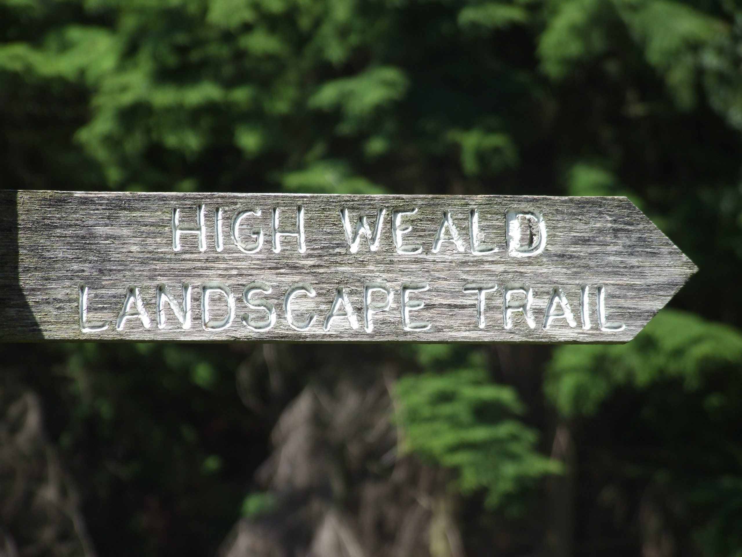
High Weald Landscape Trail
Looking for a challenge?
Take on our iconic 145km (90 mile) route that meanders through the AONB from east to west, linking ridge-top villages and historic gardens for which the area is famous.
QUICK LOOK:
- Length: 145 kilometres (95 miles)
- Start point: Railway Station, Horsham
- Finish point: Strand Quay, Rye
- Days to complete Trail: 7 days on average
- Highest point: West Hoathly, 183 m (600 ft)
- Explorer maps: 134, 135, 136, 125
Walking in the Weald
The High Weald is a working landscape and many rights of way pass through farmland – you may come across chickens, cattle, sheep, horses – or even alpacas! Please follow the countryside code and be respectful of our hardworking farmers.
Hooray for clay!
The clay paths of the High Weald can be notoriously muddy at all times of year so waterproof boots are recommended unless you’re exploring a country park.
What to wear
Be prepared for changeable weather by carrying waterproofs in a rucksack. Trousers can be useful in providing protection against any high or prickly vegetation or rain-drenched or dewy crops. They can also protect against ticks – find out how to be tick aware here.
Find your way
It’s always best to take an OS map to find your way in the High Weald. Footpaths can become overgrown quickly – or diverted – so we can’t guarantee any of the walks on our website are 100% up to date.
As the High Weald is a large area it is covered by several maps:
Explorer Series, scale 1:25,000, 2 1/2 inches to 1 mile (4cm to 1km )
123 South Downs Way
124 Hastings and Bexhill
125 Romney Marsh
134 Crawley and Horsham
135 Ashdown Forest
136 The Weald
147 Sevenoaks and Tonbridge
Keep yourself and others safe
We ask everyone to act responsibly and enjoy the benefits that nature offers, while giving it the respect it deserves.
You can also support farmers by sticking to the marked footpaths, being careful not to trample on crops, leaving gates as you find them and ensuring we all practice the countryside code values of ‘Respect – Protect – Enjoy’.
Waymarking
Where rights of way leave the road, metal or wooden finger posts, or a stone plinth indicate the way. At other points, such as field boundaries or path junctions, footpaths are marked with short posts or taller finger posts.
In addition to the posts, public rights of way in Kent and East Sussex are usually marked with small coloured arrows to show the status of the path and direction.
In West Sussex the classification of the rights of way is carved in words in the finger post. If the status of a path changes along its length, so does the colour of the arrows or the wording on the finger post. Where a right of way is a promoted path, the arrows are used in conjunction with the route’s own symbol.

