Planning and development
The High Weald National Landscape team works on behalf of its Joint Advisory Committee (or Partnership) to provide advice on how to conserve and enhance the area.
UPDATE: National landscapes rebrand
You may have noticed that the High Weald AONB has been renamed the High Weald National Landscape, and we have a new logo on our website. This came into effect on 22 November as part of a national rebrand of all Areas of Outstanding Natural Beauty in England and Wales to become National Landscapes.
However, the High Weald National Landscape remains an Area of Outstanding Natural Beauty insofar as all policy, legislation and guidance applies to the designated landscape. The statutory purpose of the designated landscape “to conserve and enhance the natural beauty of the designated landscape” remains unchanged and the High Weald AONB Management Plan 2019-2023 remains valid. This change is endorsed by Natural England.
Our role in Planning
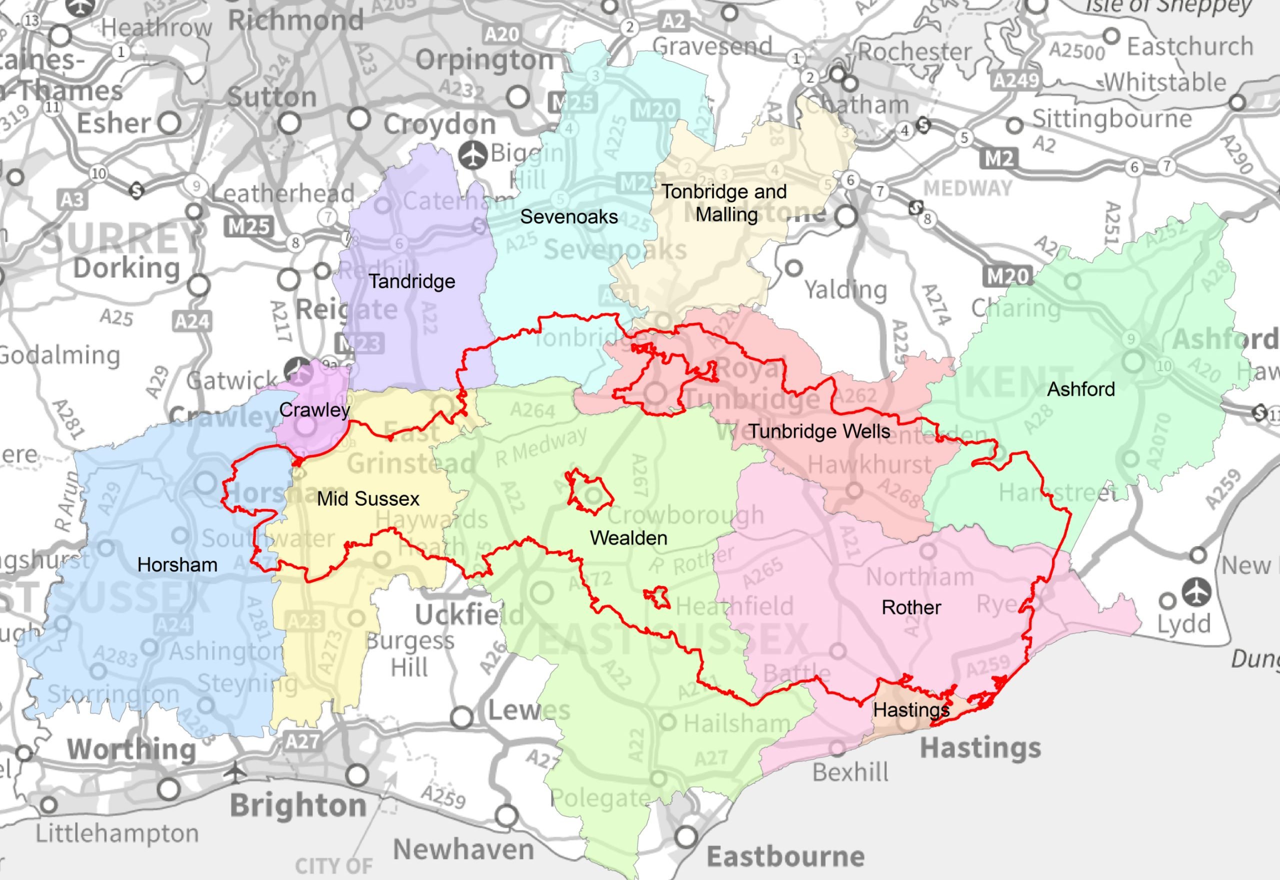
The High Weald is split across 15 local planning authorities (LPAs) – four county councils, and eleven district or borough councils.
These LPAs have the responsibility for planning policy and development management functions. Like all public bodies, local authorities have a legal duty in carrying out their functions to seek to further the purpose of conserving and enhancing the natural beauty of the AONB.
So, unlike National Park authorities, the High Weald Joint Advisory Committee (or Partnership) is not a local planning authority and the responsibility for determining planning applications remains with the 15 local authorities.
The advice provided by the High Weald National Landscape team assists local authorities and other organisations to meet their duty as set out in Section 85 of the Countryside and Rights of Way Act 2000 to seek to further the the purpose of conserving and enhancing the natural beauty of AONBs in making decisions that affect it.
For more information on what planning matters we can and can’t get involved with, click here.
What does the AONB designation mean and how does it influence planning?
Local authorities, along with other public bodies and statutory undertakers, have a legal duty under Section 85 of the Countryside and Rights of Way Act 2000 to seek to further to the purposes of the AONB designation in carrying out their planning and other functions.
In terms of planning, this means that the planning decisions and planning policy made by the Local Planning Authorities should seek to further the AONB’s purpose of conserving and enhancing the natural beauty of the landscape.
This is confirmed in national planning policy, set out in the National Planning Policy Framework (NPPF). This contains specific reference to AONBs, setting out that great weight should be given to conserving and enhancing landscape and scenic beauty in AONBs.
The High Weald AONB Management Plan defines what we mean by natural beauty in the High Weald and sets out objectives for the management of the area. The Plan has been adopted by all 15 councils with land in the High Weald and is a ‘material consideration’ in planning applications.
Responsibility for Local Plans and planning applications
The 11 local district or borough councils are responsible for preparing the Local Plan for their area and for taking decisions about most planning applications.
Minerals and Waste Local Plans are prepared by the four county councils, and they will also determine any planning applications for this type of development.
Town or parish councils may also prepare a neighbourhood plan for their parish – the website of the relevant district or borough council will include information regarding any neighbourhood plans in their area, and the status of these.
The policies in Local Plans and Neighbourhood Plans, together with the National Planning Policy Framework (NPPF) and the National Planning Practice Guidance (NPPG), will be used to inform planning .
Any comments or objections regarding a planning application affecting the AONB that a member of the public wishes to make, must be made direct to the relevant Local Planning Authority.
Planning : What we DO
- We prepare the High Weald AONB Management Plan which defines what we mean by natural beauty in the High Weald and sets out objectives for the management of the area. The Plan has been endorsed by all 15 Councils with land in the High Weald and is a ‘material consideration’ in planning applications.
- We influence planning policies by providing advice to Local Planning Authorities on how proposed policies and supplementary planning guidance would help deliver the objectives of the Management Plan, and how proposed site allocations would affect the ‘natural beauty’ of the High Weald.
- We provide advice to Local Planning Authorities on how a development proposal would affect the ‘natural beauty’ of the High Weald. This supports planning officers in making decisions on planning applications. However, we are a very small team and need to be selective about which applications we get involved with, in order to manage our limited resources and direct them where most needed.
- We provide training and capacity building within Local Planning Authorities to help them understand the natural beauty of the High Weald AONB and assess the impacts of proposals on this.
- We prepare specialist pan-High Weald guidance documents and research to help Local Planning Authorities with planning policy formulation and development management responsibilities. Recently this has included preparing the High Weald Housing Design Guide.
- We provide advice to Neighbourhood Planning Groups to help them develop plans which help deliver the objectives of the Management Plan.
- Input to national policy and guidance, primarily through working with the National Landscapes Association (previously the National Association for AONBs).
Planning: What we DON’T DO
- We cannot determine planning applications. We are not a local planning authority and the responsibility for determining planning applications remains with the 15 local authorities.
- We are not a statutory consultee on planning matters. It remains each local planning authority’s decision as to whether or not they seek our advice on a particular planning application.
- We don’t get involved in local campaigns against proposed developments. However, members of the public are welcome to use relevant parts of the AONB Management Plan in their objections to Local Planning Authorities (LPAs).
- We don’t raise objections to planning applications to LPAs on behalf of others, and we cannot forward to the LPA other people’s objections. These should be made directly to the relevant LPA.
- We don’t give site-specific planning advice direct to members of the public or developers. You will need to contact your local planning authority for pre-application advice on any development you are considering. However, we strongly advise you use the Management Plan and, where relevant, the Housing Design Guide and Colour Study, to influence your proposals.
Further Guidance
High Weald Planning Advice Note
We have produced an Advice Note which aims to assist all those involved in development proposals – including decision-makers, developers and their agents as well as members of the public – consider the impact of the proposed changes on the AONB.
High Weald Housing Design Guide
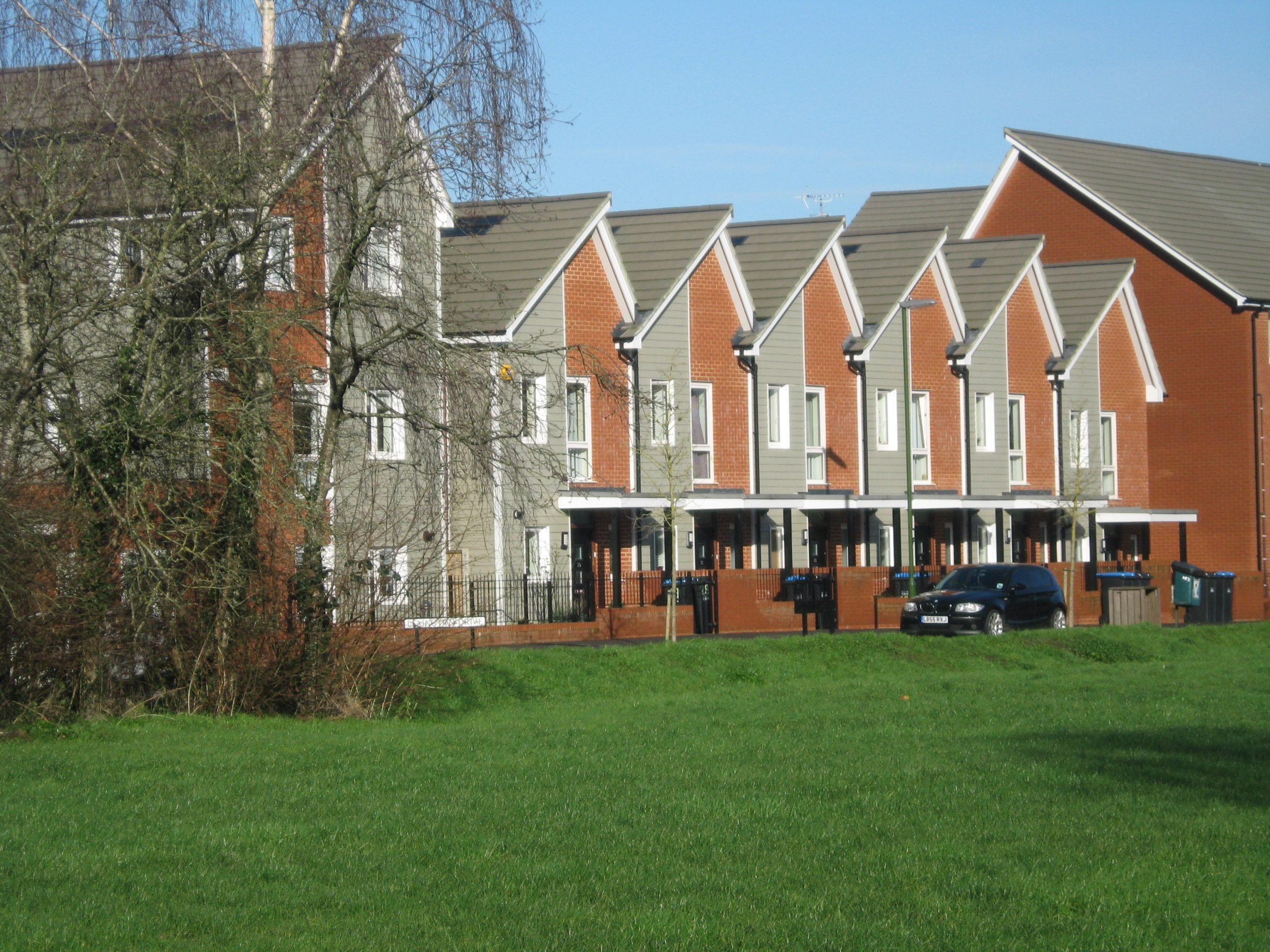
This guide provides clear, practical and consistent advice on design expectations for new housing development within the AONB, to help ensure higher quality and landscape-led design that reflects intrinsic High Weald character, and is embedded with a true sense of place.
This guidance is for all those involved in housing developments within the High Weald, from designers, developers and highways engineers, through to planning decision makers.
Find out more about the Guide, including how it was prepared, by clicking the link below.
High Weald Colour Study

This study documents the existing colours in the High Weald landscape and provides advice on what colours can be used in new development to help to integrate it into the landscape successfully.
Includes detailed colour palettes as well as advice on recommended materials and suppliers.
High Weald Parish Maps
You can use our Parish Information Maps to refer to information about the AONB landscape character in your specific area – including ancient woodland, sandstone outcrops, historic field boundaries, historic routeways, and wildflower meadows.
Our publications library holds a set of maps for each of the 99 parishes in the AONB.
Click the button to find and download information for your parish.

The Planning Portal – navigating the planning system
The planning process can seem overwhelming, but the national Planning Portal website provides lots of information on how you can get involved, from finding out about planning applications to getting involved with Local Plans.
Get in touch
Can’t find the information you need? Find details for the High Weald AONB team and every planning authority in the AONB on our Contacts page.

